Satellite imagery incorporated with GIS can give project managers a birds-eye view of oil and gas exploration and development operations and aid in the monitoring of producing fields without being present and supports the assessment of facilities, pipeline corridor planning, emergencies and hazards which can reveal potential risks for sensitive areas.
GIS Mapping Services

Remote sensing and GIS
Satellite Imaging Corporation (SIC) combines orthorectified satellite imagery with extracted vector data and client-supplied geospatial data to create single, geographic informations systems (GIS) data-rich maps for various industry applications including remote sensing in agriculture, remote sensing in disaster management, remote sensing in energy and remote sensing in environmental monitoring.
SIC incorporates GIS data to achieve a multi-layered result for many types of analysis and management pertaining to your project.The expertise and accuracy of our GIS mapping services precludes nearly all potential problems associated with GIS maps.
Satellite image for oil and gas exploration

Copyright © DigitalGlobe and processed by Satellite Imaging Corporation.
High resolution <1m satellite map mosaics and 2m-5m DEMs provide operators with the appropriate planning tools for the layout of 2D and 3D seismic surveys. By selecting good source offset locations, seismic data quality can improve and by selecting good access to seismic lines, environmental impact and safety risks are minimized.
Remote sensing images in oil and gas industry development

Copyright © Satellite Imaging Corporation
SIC creates powerful interpretation tools for mapping and GIS projects that show the “big picture.” During the planning survey, these data-filled maps are invaluable to plotting the pipeline courses, identifying potential problem areas, and determining strategy for laying pipeline through rural, mountainous, or environmentally harsh areas.
A high resolution <1m satellite map mosaics and 2m-5m DEMs provide operators with the appropriate planning tools for the layout of 2D and 3D seismic surveys. By selecting good source offset locations, seismic data quality can improve and by selecting good access to seismic lines, environmental impact and safety risks are minimized.
After retrieval of your satellite imagery for the proposed drill site, your geological and seismic interpreted geology information is supplemented with extraction of vector data such as current and proposed well positions, field data, geochemical data, elevation data, environmental habitats and more, creating a complete picture of the potential work site.
Satellite Images for Oil and Gas Production
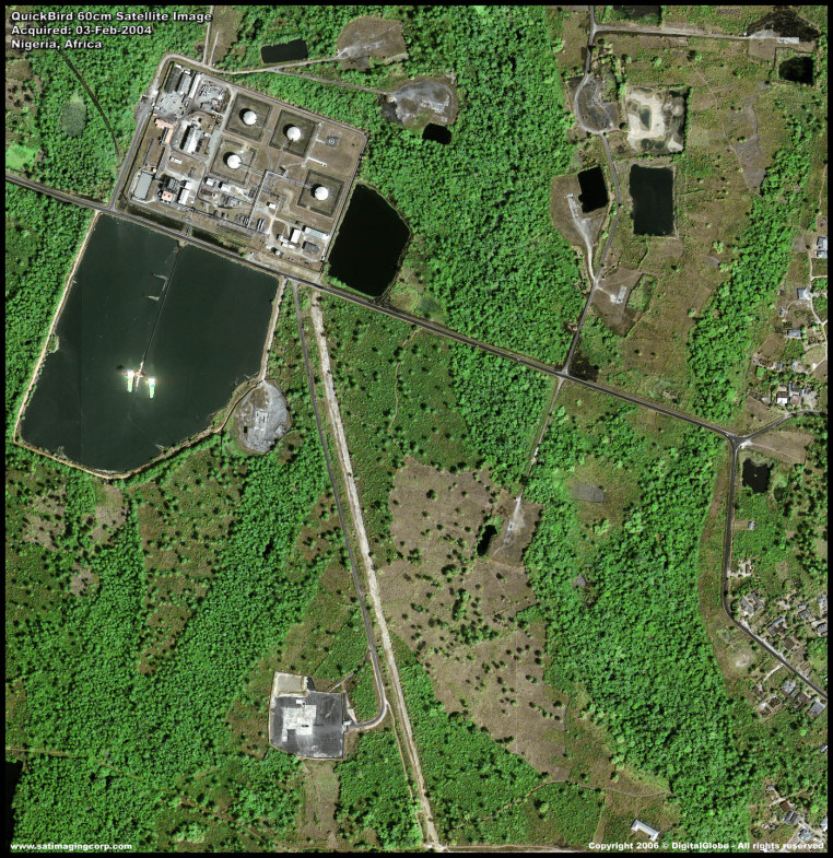

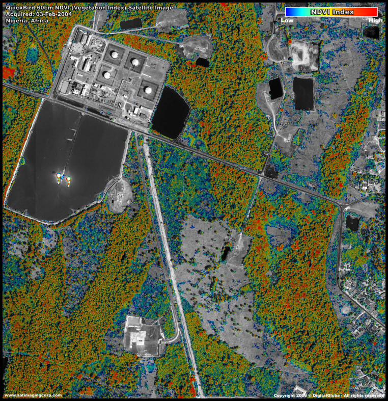
Image processing services provided include Spectral Analysis to support environmental monitoring.
Left to right: Vegetation Landcover Index, Soil Zone Index, Vegetation Hue Colorized.
Image Credit © DigitalGlobe
Satellite images for oil and gas production, accurate tracking of your oil and gas project is imperative to its success. Accountability to upper levels of management, as well as to environmental parties, requires that you have a clear picture of your project’s growth and its impact to the surrounding area over time.
Satellite Imaging Corporation is experienced in providing highly detailed and accurate satellite imagery and aerial photography optimized for the oil and gas industry.

Image Copyright © DigitalGlobe
Satellite images are invaluable for the detection of leakage, which regular control systems may not be able to detect. Satellite Imaging Corporation acquires high-resolution satellite imagery from 30 centimeters to 1.5-meter resolution. that can detect a spill early, saving time and money on clean up procedures.
Copyright: DigitalGlobe