Artificial intelligence in remote sensing is considered an important science. These algorithms have the ability to handle highly calculated data and establish classes with complex characteristics. Over the past few years, Machine Learning has become a major focus and development direction for remote sensing images.
What is Machine Learning?

Machine Learning and Remote Sensing
In recent years, AI – Artificial Intelligence, and more specifically Machine Learning, emerged as evidence of the fourth industrial revolution. Artificial Intelligence is creeping into all areas of life that we may not recognize. Self-propelled vehicles of Google and Tesla, the system that tags faces in Facebook’s photo, Apple’s Siri virtual assistant, Amazon product suggestion system, Netflix movie recommendation system, Google’s AlphaGo Go player DeepMind, …, are just a few of the many AI / Machine Learning applications.
Machine Learning is an area of artificial intelligence that involves research and building techniques that allow automated “learning” systems from data to solve specific problems. Machine Learning helped computers perform things that seemed impossible 10 years ago: categorizing thousands of different objects in photographs, creating captions for images, imitating human voices and scripts , communicating with people, or even writing or music.
Basically, Machine Learning algorithms are categorized into 3 types: Supervised Learning, Unsupervised Learning, and Reinforcement Learning. They have their own unique algorithms and are used for different purposes.
Types of Machine Learning algorithms
Supervised Learning: A method of using pre-labeled data to deduce the relationship between input and output. These data are called training data and they are pairs of inputs and outputs. Supervised Learning will review these training sets so that the output predictions for a new input are never met.
Unsupervised Learning: Other than Supervised Learning, Unsupervised Learning closely uses previously unbranded data to reason. This method is often used to find the structure of a data set. However, there is no method to evaluate the structure found to be right or wrong.
Reinforcement Learning: Reinforcement Learning method focuses on how to make an agent in the environment be able to act so as to get as much reward as possible. Other than Supervised Learning it does not have pre-labeled data pairs as input and does not judge whether the actions are right or wrong.
Machine Learning in Remote Sensing

Automatically detect buildings
Over the past few years, space agencies have deployed a large number of satellites on Earth orbit. Due to the large amount of information provided by satellites, users have access to a wide range of satellite image data, ranging from optics to radar, from single to multi-spectral, from commercial to free. charge.
However, to make the processing of satellite images more efficient, it is important to develop fully automated analytical methods. Machine Learning provides the potential to classify space images more efficiently and faster. Machine Learning includes many algorithms such as Artificial Neutral Network, Support Vector Machine, Self Organizing Maps and Decision Tree. These algorithms have the ability to handle highly calculated data and establish classes with complex characteristics. Over the past few years, Machine Learning has become a major focus and direction of remote sensing.
Here are some examples of Machine Learning-based solutions that have been successfully developed for remote sensing industry. Machine Learning focuses on automatically extracting information from data using calculation and statistical methods.
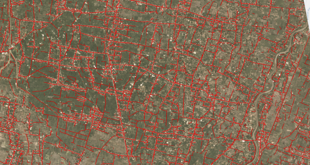
Automatically detect routes
Overall, there has been considerable progress in developing Machine Learning-based methods for many Earth Science applications. However, a big challenge for those who want to apply Machine Learning methods is data collection.
Refer: Machine Learning, Skymap Global